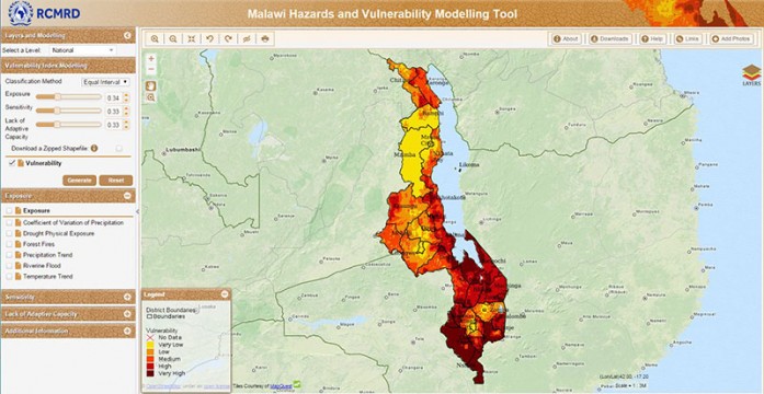
Malawi is among the countries most impacted by floods, droughts, forest fires, and variations in temperature and rainfall. The Regional Centre for Mapping of Resources for Development (RCMRD) and SERVIR-Eastern and Southern Africa have been collaborating with the Department of Disaster Management Affairs (DoDMA) in Malawi to find out just how vulnerable the country’s people are to these hazards and their effects on food security and livelihoods. RCMRD/SERVIR-E&S Africa and DoDMA compiled a
hazard and disaster database for Malawi and created a dynamic Hazards and Vulnerability Modeling Tool. The information collected and presented in the tool uses the Intergovernmental Panel on Climate Change (IPCC) conceptual framework, which separates vulnerability into three components: exposure, sensitivity, and adaptive capacity to the hazards listed above. The tool is dynamic and user friendly, allowing the user to generate his/her own vulnerability maps by assigning different weights to these three main components. All custom products generated through this option and all input datasets used to estimate each component can be downloaded in a variety of formats. During disaster periods, users with access to the photo upload functionality will be able to upload photos of situations on the ground for relief and emergency responders to view in near real-time. Read more


