In the year 2016, SERVIR Eastern and Southern Africa (E&SA)/RCMRD (Regional Centre for Mapping of Resources for Development) conducted a needs assessment for Uganda to identify the climate related issues that the country was facing. One of the issues identified during the needs assessment was the need to have a rigorous approach
in identifying deforested and degraded forest areas. This required timely and periodic Land Cover Maps and change maps that would be used to make informed decisions. The pressing need saw forth a collaboration effort with NASA’s (National Aeronautics and Space Administration) Applied Science Team (AST). Sean Healey (lead Scientist) from United States Forest Service and partners from Silva Carbon and Oregon State University together with SERVIR E&SA developed a project that would address this need.
“Enabling Local Monitoring of Landscape Change across Eastern and Southern Africa” is a three year project by the AST, which builds upon the TimeSync tool, Google Earth and Google Earth Engine. It leverages on Landsat’s archive, Google Earth’s High Resolution Imagery and Google Earth Engine’s processing capacity to integrate an ensemble of different land cover mapping algorithms. Reference data collected through TimeSync would be used to calibrate annual maps and change maps between Y2000 and the current year.
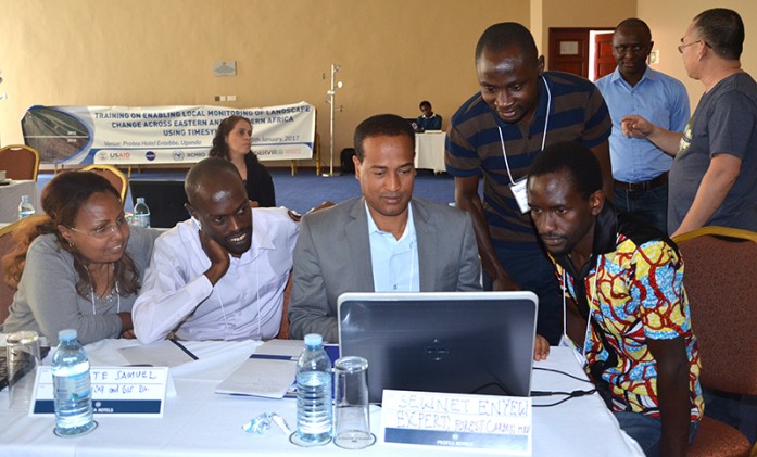
SERVIR E&SA together with the AST, recently held a capacity building and reference data collection activity in Entebbe, Uganda from 23rd to 25th January 2017. Participants (22) were drawn from Rwanda, Zambia, Malawi, Ethiopia, Kenya and the majority from Uganda. Mostly from: Ministry of Natural Resources, Energy and Environment – Department of Forestry, Malawi; Ministry of Lands, Natural Resources and Environmental Protection –Survey Department, Zambia; Rwanda Natural Resources Authority(RNRA); Ethiopia Mapping Agency, Ministry of Environment, Forest and Climate Change, Ethiopia; National Forestry Authority, Uganda; Makerere University, Uganda, Climate Change Department (CCD), Ministry of Water and Environment, Uganda; Climate Change Department (CCD), Ministry of Water and Environment, Uganda, Kilimo Trust, Uganda; NEMA, Uganda, REDD+ Uganda; DRSRS, Kenya; Kenya Water Towers Agency (KWTA); Kenya Forest Service; and USAID-USFS – Kenya Water Tower Climate Change Resilience Program.
In the three days training, the participants were trained on reference data collection using TimeSync. TimeSync is an application that allows researchers and managers to characterize and quantify disturbances and landscape changes by facilitating pixel level interpretation of Landsat time series stacks of imagery. TimeSync was created in response to research and management needs for time series visualization tools, fuelled by rapid global change affecting ecosystems, major advances in remote sensing technologies and theory, and increased availability and use of remotely sensed imagery and data products (Cohen et al., 2010). TimeSync can be used to characterize the quality of land cover map products derived from Landsat time series; derive independent statistical estimates of change with uncertainty, including type of change over time and rates of change; validate change maps; and explore the value of Landsat time series for understanding and visualizing change on the earth’s surface.
Participants found TimeSync’s ability to monitor miniscule changes including phenological differences occurring over very short durations to be of great value. The project’s 1st year activity is mostly reference data collection. During the three days training, the participants learned how to use TimeSync and how to customize the response design. The response design was determined to be applicable to all 7 countries covered by the project: Kenya, Uganda, Rwanda, Zambia, Ethiopia and Malawi. The response design enables to not only record the state of the individual years, but also determine the change process that may have occurred in between the different vertices.
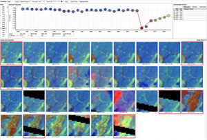
Figure 1. Illustration of the time series of Landsat archive used to interpret forest disturbance history through the TimeSync interface. The trajectory indicates a forest state that had been stable for some time, then some deforestation happened and has been greening in the last few years.
The reference data collected during the workshop was used to demonstrate how areas and error estimates for the different covers and change statistics can be derived. Albeit very few points were available from the training for Uganda (266), the trend was corroborating what has been determined by other data sources and existing Land Cover maps. It is expected that more reference data will continue to be collected over time to reduce the uncertainty of land cover change estimates. Some of the participants indicated that Time Sync will go a long way in enriching how they collect reference data and change analysis. Another participant saw the possibility to use the tool in Forest restoration programs that are currently going on given its ability to detect very small deforestation areas. SERVIR E&SA led the training, and is now capable of running similar workshops in other countries. In addition, SERVIR E&SA’s programmer worked with TimeSync’s developers and gained the ability to modify the software so that it can be customized for other reference data collection activities in the Region.
Get more information here
Read also Tracking the changing landscape of Eastern and Southern Africa


