Today, the analysis and use of satellite images is common. However, 15 years ago, only a handful of specialists worked with these valuable data. Since then, a particular niche expertise has rapidly developed – the use of satellite data for disaster management. In this regard, Denis Macharia, an environmental and geospatial scientist working
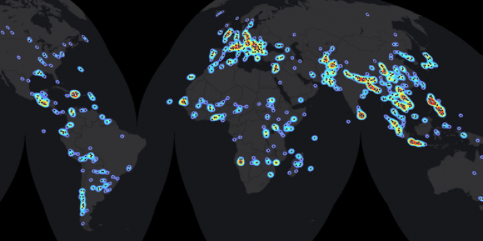
at the Regional Centre for Mapping of Resources for Development (RCMRD) teamed up with a group of scientists from various international agencies led by Dr. Stefan Voigt, a remote sensing expert from the Deutsches Zentrum für Luft- und Raumfahrt (DLR) Earth Observation Center (EOC) in Oberpfaffenhofen to analyze the historical development of satellite-based emergency mapping. In the current special edition of the journal Science, the researchers are presenting global patterns alongside historic and emerging trends in this field. To conclude their analysis, the scientists studied more than 1000 disaster relief activations around the world between 2000 and 2014, creating a unique database in the process: “This database – which is in essence a cadastre of global satellite-based emergency mapping – allows us to study global patterns and trends in the community. This way, we can provide even better support in emergency situations, while also improving our global decision-making and cooperation. It would be extremely instrumental to further maintain this database so we can keep an eye on future trends and developments” says lead author Dr. Stefan Voigt. Read full story here
Reference
Global Trends in Satellite-based Emergency Mapping


