The Regional Centre for Mapping of Resources for Development (RCMRD), with support from the United States Agency for International Development (USAID) and the National Aeronautics and Space Administration (NASA) awarded nine research grants to researchers from organizations in Rwanda, Tanzania, Uganda and Kenya, under the second phase of the SERVIR E&SA Small Grants Program, whose implementation started in April 2019. Through this support of local partners, the objective of the Small Grants Program was to expand the network of organizations who generate innovative ideas on the use of Earth observation (EO) data and geospatial methods/tools for development decision-making in the Eastern and Southern Africa region. The anticipated outcome of the grant activities was to improve the capacity of local organizations to use geospatial tools and information to translate science into sustainable policy and practice in order to address the development challenges posed by environmental and climate stresses.
With support from the SERVIR Support Team (SST), RCMRD processed 41 applications from organizations in East Africa, based on the ability of their proposals to use EO data, GIS and geo-spatial analysis to address societal development challenges in four thematic areas: (i) agriculture & food security, (ii) land use/land cover & ecosystems, (iii) water resources & hydro-climatic disasters, and (iv) weather & climate. Ultimately, nine grantees were selected to implement work within a period of 9-12 months, summary details related to each grantee is provided in the following table:
|
Project PI |
Project Title |
Organization |
Country |
|
Mr. Fred Lali |
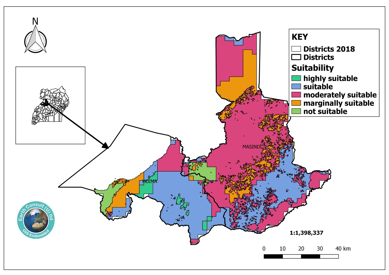
Building the capacity of National Agricultural Research Organization institutes in integrating geospatial tools for climate-smart precision agriculture |
Earth Consult (U) Ltd. |
Uganda |
|
Mr. Laban Musinguzi |
Strengthening Capacity for Utility of geospatial information in management of freshwater biodiversity and fisheries in Uganda |
National Fisheries Resources Research Institute (NaFIRRI) |
Uganda |
|
Ms. Shukuru Nyagawa |
Conducting an assessment of climate change vulnerability using GIS tools and enhancement of community adaptive capacity in Chalinze District, Tanzania |
E-Link Consult |
Tanzania |
|
Dr. Guido Uhinga |
Integrating hydraulic modelling with participatory GIS to assess flood risk in Dar es Salaam, Tanzania to enhance community resilience |
Ardhi University |
Tanzania |
|
Mr. James Mbugua |
Bringing coral reef and coastal ecosystem data into country decision making in Kenya |
Coastal Oceans Research & Development Indian Ocean (CORDIO) East Africa |
Kenya |
|
Dr. Richard Muita |
Strengthening community understanding and uptake of climate forecasts interfaced with indigenous knowledge systems in Kenya to promote agriculture adaptation to the effects of climate change and variability |
Kenya Meteorological Society |
Kenya |
|
Ms. Margaret Wambua |
Leveraging citizen science in invasive species data collection and management in northern Kenya rangelands |
Laikipia Wildlife Forum |
Kenya |
|
Ms. Lillian Nyaega |
Applying geospatial data in water resource management for sustainable ecosystems and improved livelihoods in the Mid-Athi catchment. |
Wetlands International Kenya |
Kenya |
|
Mr. Davis Bugingo |
Applying Earth observation technology to improve water resource management in the upper Nyabarongo and Mukungwa catchments |
Rwanda Forest Authority (RFA) |
Rwanda |
Ardhi University and NAFIRRI were funded as in-kind grantees. The other six were fixed grant awards. Unfortunately, the grant to the Rwanda Forest Authority was cancelled due to unforeseen logistical and budgetary challenges associated with delays from COVID-19 restrictions and was unable to be completed. This was a result of circumstances outside of the grantee’s control and did not reflect in any way on the grantee’s performance in the proposed work.
Having completed implementation of activities, the SST organized a virtual closeout workshop held on January 18, 2022, where the 8 grantees presented their findings and the outcomes of their interventions. Opening remarks were provided by the RCMRD Director General, Dr. Emmanuel Nkurunziza and USAID Kenya & East Africa’s Program Management Specialist (Climate Change and Resilience), Ms. Chihenyo Kangara. Other attendees included RCMRD staff and distinguished guests from USAID and NASA. During the workshop’s opening session, the SST Chief of Party Mr. Anthony Panella applauded the grantees for their relentless efforts in continuing to implement their grant activities during times of unprecedented challenges related to the global pandemic. He also acknowledged the support from the SERVIR project leadership at RCMRD, USAID and NASA. Ms. Kangara underscored the importance of implementing the findings from the grantees work, and also emphasized that USAID was committed to increasing the ability of African institutions to use Earth observation and geospatial technologies to improve the resilience of the region to the impacts of climate change and ensure sustainable resource management. Dr. Nkurunziza thanked the SST for successfully coordinating the grants work under a very challenging time throughout the world. He appreciated the support from USAID and NASA, and also commended the grantees for accepting to work with RCMRD and SERVIR to find solutions to challenges that are affecting the E&SA region under various livelihood sectors. The Director General also assured the grantees that as RCMRD partners, the organization would continue to make every effort to support the work they were doing to improve lives and livelihoods in member States. The eight grantees’ presentations during the closeout workshop are summarized as follows: The National Fisheries Resources Research Institute (NaFIRRI) grant increased the institution’s capacity to collect and use remote sensing data for monitoring key indicators of water and catchment conditions, to monitor water quality parameters such as algae and freshwater biodiversity. The PI also reported on the improved capacity to process data, produce maps and provide analysis to better predict aquatic habitat conditions and improve natural resource management. While the initial plan was to examine the influence of land cover change on aquatic habitat conditions & biotic communities and forecast future conditions using both remote sensing data and in-situ observations, the grant was modified to also support acquisition of equipment.

The E-Link Consult project aimed to conduct vulnerability assessments and hotspot mapping in Chalinze District using GIS tools and to develop practical climate change adaptation interventions. Through support from the SERVIR grant, E-Link Consult produced valuable data sets and maps, which were shared with various relevant stakeholders and levels within the District including policy and decision makers for effective communities’ adaptation to climate change impacts. Through a tailor-made participatory process, strategic adaptation interventions were developed and supported in one hotspot village in Chalinze district. Following use of data-driven evidence, the grantee demonstrated that more villages were vulnerable to climate impacts, thus increasing the known hotspots from one to five. The Project Team conducted participatory planning meetings with the District Officers who also advised the project to consider 10 community groups in five villages within the Talawanda Ward for the proposed adaptation interventions. This research contributed valuable information to the newly formed Chalinze District in spearheading the development agenda in light of climate change impacts and vulnerability knowledge, thus building community resilience and embracing sustainable development agenda.

Vulnerability impact assessment maps produced by E-Link Consult, which offered valuable data sets and maps to guide adaptation actions in the newly created Chalinze District.
Wetlands International Kenya applied geospatial data in water resource management for sustainable ecosystems and improved livelihoods in the mid-Athi catchment. This grantee aimed to develop and make available a reliable data monitoring system for stakeholders to inform decision making for improved water resources management, sustainable livelihoods and strengthened community resilience. The evidence produced from the collected geo-data will be used to develop a business case that will influence private sector institutions to make business decisions that take into account social and environmental safeguards.
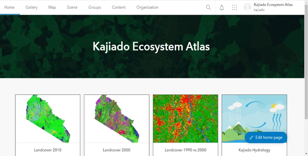
The Kajiado Ecosystem Atlas
The Kenya Meteorological Society (KMS) strengthened community understanding and uptake of climate forecasts interfaced with indigenous knowledge systems in Kenya to promote agriculture adaptation to the effects of climate change and variability. The grantee addressed lack of reliability in data by demonstrating how in-situ observations and knowledge held by vulnerable communities can be used to address these gaps. KMS also developed the capacity to use the climate information through community engagement. The grantees activities included data collection, use and analysis using field surveys, face to face interviews, community engagements, and meetings with key informants in Machakos and Kakamega Counties.
The Laikipia Wildlife Forum (LWF) leveraged citizen science in invasive species data collection and management in northern Kenya rangelands. The grantee mapped invasive species, particularly Opuntia stricta and Acacia reficiens in areas of northern Laikipia rangelands as part of their control and management efforts. This was part of a wider effort to improve rangelands on pastoralist community lands. This mapping and monitoring effort used a mobile device-based application pioneered by SERVIR E&SA to facilitate data collection in remote areas through citizen science.

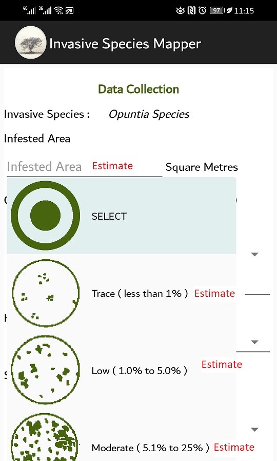
(Left) Map showing Opuntia stricta prevalence in Laikipia County, Kenya (Right) Some features in the Invasive Species Mapper application developed by RCMRD
The Coastal Oceans Research & Development in the Indian Ocean (CORDIO) East Africa facilitated the use of coral reef and other coastal and marine information in core sectors (ecosystem health, food provisioning, economic development and disaster prevention) to support the Kwale County government’s planning and decision making. This was done by compiling the relevant information and making it accessible to the County government and the public where possible, and by developing policy-relevant integrated indices that can integrate uptake of data products in decision-making circles. Working with the relevant government officials, the project identified and developed outputs designed for improving their internal development decision making processes, such as integrated spatial development planning documents.
![]()
Map showing zones of key maritime activities such as fishing, mining and transport, protected areas and threat status of coral reefs in Kwale County , Kenya.


