
RCMRD,AGRA, Advanced GIS & Introduction to Remote Sensing Training in Burkina Faso
The Alliance for a Green Revolution in Africa (AGRA) and the Regional Centre for Mapping of Resources for Development (RCMRD) jointly conducted an Advanced GIS and Introduction to Remote Sensing training for the Ministry of Agriculture and Rural Development (MAAH) in Koudougou, Burkina Faso from January 25, 2021 to February 5, 2021. The training had a total of 26 participants (23 males and three females).
The training was conducted under the Building the Capacity of Ministry of Agriculture to Monitor Agricultural Value Chain Investments Using GIS And Earth Observation Information implemented at RCMRD. The opening remarks were made by MAAH Directeur du suivi, de l'évaluation et de la capitalisation (DSEC), Mr. Oula Damien OUATTARA, and RCMRD''s facilitators included GIS Analyst Mr. David Ongo and Data Analyst Ms. Angela Too.
This was a third training in a series of trainings lined up under the AGRA project. The training covered Advanced GIS, introduction to remote sensing for Agriculture and a recap of an online training previously done. This training was setting a tone for subsequent trainings that would enhance the capacity of the ministries in the application of Earth Observation in Agriculture. The goal in this training was to equip the participants and encourage the use of geospatial technologies in improving agricultural reporting and integration of agricultural data into a central database for policy and evidence-based decision making.

Figure 1: Training Participants from the Ministry of Agriculture and Rural Development (MAAH), Burkina Faso
The training session methodology was structured to take fourteen days and was based on enabling the use of customized manuals using country data sets for ease of understanding. The two-week training encompassed a slightly advanced GIS Analysis and introduction to Remote Sensing. The training module was structured to enable participants from the MAAH to convert any spatial data they have into geospatial format complete with metadata, design and manage databases and finally source for and process medium resolution satellite imagery for monitoring purposes. The participants were introduced to statistical analysis using earth observation data that can also be utilized in monitoring climatic trends, vegetation vigour and drought monitoring. In addition, participants were taken through the art of map making.
As part of the program support, two laptops we handed over to the MAAH Director General & Director Monitoring & Evaluation as part of the continuous equipping of the ministry through provision of efficient equipment for the processing of Earth Observation data.
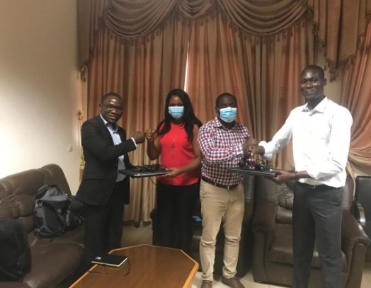
Figure 2: The handing over of the laptops to the MAAH team
Mr. Ouedraogo Abdoulaye from AGRA Burkina Faso office paid a courtesy visit during one of the training sessions held at Splendid Hotel Koudougou, Burkina Faso. The RCMRD staff gave him a brief status of the project and the general performance of the training. The RCMRD staff also visited Ouagadougou to undertake a Covid-19 test, where they also used to the opportunity to pay a courtesy call to on the AGRA country office and were received by Mr. Raul Ouedrago, country representative AGRA Burkina Faso. They gave a brief on the status of the project which the country representative appreciated. According to him, Burkina Faso is a champion in this project and the momentum should be carried to the end of the project.
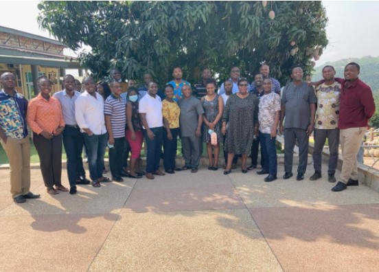
Figure 3: Group photo of the Training Participants
During the training, the trainers the opportunity to talk about the Digital Earth Africa. The participants were taken through general information about DEA in addition to a platform, data, sandbox and the trainings currently in the website.
It was recommended that for the future trainings, participants should have laptops with better processing power that can handle large imagery data processing. Women participants were also encouraged to take part in training. Participants had positive feedback on the training and they said they use the skills gained in their daily reports. It was agreed that there was need have a follow up training on remote sensing as this was an introduction. The participants also said the two weeks training gave enough time to cover all topics and exercises on time.
Among the challenges experienced was that some participants laptops had low processing power hence it took a longer time to process the data. At the same time, the proportion of female to male participants was too low.


